Smoke Blankets Oregon - NASA Science
3 min readImage of the Day for July 28, 2026Lightning storms have ignited dozens of fires in central and eastern Oregon. NASA Earth ObservatoryJul 28, 2026ArticleView more Images of the Day:Dry thunderstorms. . .
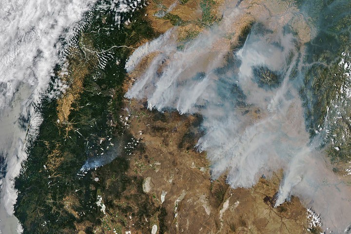
3 min readImage of the Day for July 28, 2026Lightning storms have ignited dozens of fires in central and eastern Oregon. NASA Earth ObservatoryJul 28, 2026ArticleView more Images of the Day:Dry thunderstorms that popped up over theCascade Rangeon the evening of July 15, 2026, peppered Oregon and Washington with thousands oflightning strikesas they moved east across the states. By the following day, NASA satellites hadbegun to detectlarge numbers of wildland fires burning throughout central and eastern Oregon. Though initially small, these blazes strengthened as they were fanned by gusty winds and raced through landscapes parched byextreme droughtand baking in summer heat. When NASA’sAquasatellite captured the image shown above on the afternoon of July 26, smoke poured northeast from dozens of large fires that had collectively charred hundreds of square miles. The fires produced a blanket of haze, prompting state officials to issueair quality advisoriesfor eastern Oregon. Many communities faced evacuation orders as more than 10,000 firefighters battled wildfires throughout the state. On the day the image was captured, the largest active fires were the Hay Creek Complex, Brewer, Big Grass, Akawa Butte, and Powder River fires. Several of these blazes were less than 5 percent contained, according to theNational Interagency Fire Center. State officials invoked Oregon’s Emergency Conflagration Act to protect communities as they responded to particularly threatening fires such as theShingle, Bench, Beachcomb, and Second Flatfires. Government satellite data are part of a global system of observations used to track fire behavior and analyze emerging trends. Among the real-time wildfire monitoring tools that NASA makes available areFIRMS(Fire Information for Resource Management System), theWorldviewbrowser, and theFire Event Explorer. As of July 27, 2026, fires in Oregon had burned more than one million acres, according tonews outlets. Meanwhile, theNational Interagency Fire Centerreported that fires had burned more than 4 million acres across the United States. The 10-year average (2016-2025) for this point in the season is 3. 4 million acres. NASA Earth Observatory image by Michala Garrison, using MODIS data from NASAEOSDIS LANCEandGIBS/Worldview. Story by Adam Voiland. DownloadsJuly 26, 2026Central Oregon Fire Info (2026, July 27)The Source For Comprehensive Fire, Health, And Air Quality Information In Central Oregon. Accessed July 27, 2026. KGW8 (2026, July 27)Latest updates on Oregon wildfires: Fires burn more than 1 million acres across the state. Accessed July 27, 2026. NASA Earthdata (2026)Wildfires. Accessed July 27, 2026. National Interagency Fire Center (2026)Oregon. Accessed July 27, 2026. Northwest Interagency Coordination Center (2026, July 27)Official Fire Information. Accessed July 27, 2026. OPB (2026, July 27)Oregon wildfires explode over weekend with no signs of slowing down. Accessed July 27, 2026. Oregon State Fire Marshal (2026, July 27)OSFM Wildfire Info. Accessed July 27, 2026. Oregon. gov (2026, July 26)Current wildfire info. Accessed July 27, 2026. Oregon Smoke Information (2026, July 27)Air quality advisory for Eastern Oregon and parts of Central Oregon. Accessed July 27, 2026. Oregon Department of Forestry (2026, July 27)Latest News. Accessed July 27, 2026. U. S. Drought Monitor (2026, July 21)Oregon. Accessed July 27, 2026. You may also be interested in:Stay up-to-date with the latest content from NASA as we explore the universe and discover more about our home planet. Fires Tear Through Nebraska Grasslands3 min readDry, warm, and windy conditions across the U. S. Great Plains led to extreme fire activity in March 2026. ArticleCottonwood Fire Chars Utah5 min readThe blaze burned more than 150 square miles and swept through parts of a ski resort. ArticleFires Rage in Georgia3 min readFirefighters are battling two destructive blazes in the southern part of the state as drought grips the U. S. Southeast. ArticleKeep ExploringDiscover More from NASA Earth Science